Wednesday, January 28, 2015

Ohio in the Anthropocene

Some specialists say that we are in a true environmental crisis due to our lasting effects on Earth. The new label for human kind disrupting the atmosphere, as well as causing polluted oceans and the extinction of plant and animal species, is "Anthropocene". This new word would put an end to the earlier "Holocene" epoch that started after the ice age 11,700 years ago. Parts of this epoch include rise in river sedimentation and soil erosion due to the loss of agriculture and spread of industrialization through the last 250 years. The difference in the physical and chemical framework can be seen all around from the soil deposits and what exactly are in the fossils. Having many instances at different points in time at the local level effect the landscapes that interacting together. Igneous, metamorphic and sedimentary rocks lie deep beneath the surface of Ohio, covered by thick layers of younger sedimentary rocks. These deeply buried rocks form the foundation on which ancient bodies of water deposited the layers of sedimentary rock that we see today on the surface. And the upper sedimentary layers provided the foundation on which Ohio’s soils of today developed.  The relatively recent upper region contains soil mixed with material dropped by the great glaciers. The glaciers moved the then Teays River and created the now Ohio River leaving material behind. 

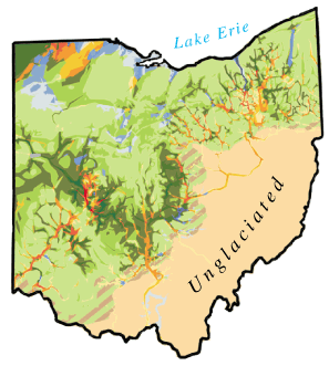
Most recently our landscape is covered by agriculture (see land cover maps below).
Figure1. Ohio 1992 National Land Cover Data Sheet. http://wwwapp.epa.ohio.gov/dsw/nps/NPSMP/photos/ohio_92nlcd.jpg


Figure 2. Ohio Land Cover. http://wwwapp.epa.ohio.gov/dsw/nps/NPSMP/photos/ohio_94.jpg


This in part obviously affects nature itself but also rivers in Ohio. For example here today farm runoff from the fertilizer has affected and contaminated the Ohio River. 


Wave erosion acton on clay bluffs 1 of 3
Wave erosion acton on clay bluffs 2 of 3
Wave erosion acton on clay bluffs 3 of 3
Figure 3. Waves from Lake Erie and its impact on Ohio's coastal erosion. http://geosurvey.ohiodnr.gov/lake-erie-geology/erosion-and-research/erosion-problems


A very large cause of the proponent of the erosion to, for example, the Ohio shoreline is caused by waves from Lake Erie. A study done by William W, Mather showed that in 1838 some of the coast from the last 42 years had lost over 130 feet. The shore is also easily swept away since the bank is so low. Waves weaken the base of a higher clay shoreline until the base of the bluff—the slope that rises from the shore to where the upper land flattens out—washes away or collapses (Ohio Department of Natural Resources). The bluff may seem stable but in reality a storm could come through at any time and cause it to collapse. This can cause the edge of someone’s backyard to taper inland even further than before. The bluff being made of soil, clay, shale, or bedrock does not matter because the bluff is so weak.

Sources:


Tuesday, January 27, 2015

Ohio During the Quaternary Period

Amanda Crawley & Emily Norrod
Nearly 66 million years ago, the Earth entered what is now known as the Cenozoic Era. This era is made up of several smaller geologic time periods including the one in which we currently reside: the Quaternary. The Quaternary time period began around 2.6 million years ago and at the beginning of this time period, the Earth’s land masses had mostly settled into their current formations with very little movement since. The most significant part of this time period in terms of geological setting is the cycle of Ice Ages which significantly transformed the Earth’s surface.

At the greatest extent, glaciers covered about 2/3rds of Ohio. As glaciers extended down, they scraped the surface of the Earth, collecting debris and rock as they went. In the reserve, as the glaciers began melting, they left deposits of unsorted sediment in their wake.


Map showing various glacial deposits.
During this time period, Ohio had no plate boundaries’ movement effecting it’s rock formations. Instead, rock formations were changed by the movement of glaciers that covered most of the state.


Glaciers, such as Jackson


The glaciers that covered Ohio slowly receded and left deposits of sediment or "glacial till" in their wake.

The rock that was deposited during the Quaternary period in Ohio came from melting glaciers which filled valleys with sand, clay, silt, gravel, and boulders. These deposits are still commonly found in Ohio to this day, making up much of the upper layers of our rock and dirt.


Information Sources:

Monday, January 26, 2015

Ohio in the Miocene

The Miocene Epoch was the fourth epoch of the Tertiary period in the Cenozoic Era, and spanned from 23.03 to 5.3 million years ago. During this time there was a warmer global climate than the previous eras, and the land that is in the center of the continent now known as North America began to dry. At this point, Ohio was above sea level and the land was exposed. This left the rocks that  exposed to the elements, which caused significant erosion.

The position and shape of the Earth's continents
appear very similar to the modern continents. 


It is believed that several hundred meters of rock were destroyed due to weathering and glacial movement.  This erased all trace evidence of animal life and left a blank space within Ohio’s geological history.

It is assumed that land animals were present in Ohio
during this time period. However, no fossils remain to
prove which species or an exact location.


Links/Sources:

Ohio During the Devonian

   
      The Devonian Period, the Age of Fishes, occurred 416 million years ago. At this point in time, the world was in two super continents; Gondwana and Euramerica. These two land masses were 
surrounded by large subduction zones, which would destroy more land as the years progressed. Vast areas of ocean covered the rest of the globe. During this time, Ohio was forming but was not yet the little piece of heaven we know and love. It was part of a super-continent Euramerica. 
 
When North America and Europe collided, large deposits of granite were formed. This period is well known for these large deposits , along with the formation of  Appalachian Mountain range. The Devonian Period gave way to red colored sediment. This red colored sediment was first studied in Devon, England; giving its name. Near the end of the Devonian period, the first large forested areas arose. This period is also known as being the time of the mass extinction of many forms of life through the destruction of a meteor impact. 

Sunday, January 25, 2015

Ohio in the Silurian Age


The Silurian Period lasted from about 443 million years ago until 416 million years ago during the Paleozoic Era (Hansen).  Glacial formations began melting off, causing the deposition of rock across the state as well as a rise in sea levels. As the water began getting deeper reef environments sprang to life, giving this time period the nickname “the Age of Corals.” With the proximity to the equator being so close, Ohio was a tropical paradise abundant with many life forms that had previously not inhabited the area (Fischer). However, one of the most interesting aspects of Ohio during this time was not its ancient animals, but its rocks. Silurian rocks on the subsurface were predominantly salt and sandstone and were in what is now Eastern Ohio (Hansen). On the western side of Ohio, the rocks were completely different. Rocks such as limestone, dolomite, shale, and gypsum were abundant and remained on the surface (“Silurian”). All of these rocks were formed from chemical precipitation because of the sodium chloride, halite, hematite, and calcium in the warm, shallow, water (Coogan). As a result of numerous reefs developing that restricted the water from flowing naturally, the salt from the sea deposited into the ground after it evaporated and made the rocks chemically precipitate (“Silurian”). The rocks formed in Clark County developed in the Silurian Period. (Behrensmeyer, 438-408) In this period there were low continental elevations and a high global standing sea level. The area was geologically filled with siltstone and limestone. There was also shale and gray mudstone sediment.

Silurian history of Ohio:
Generalized nomenclature and relationships of Silurian rocks in various parts of Ohio and their relationships to underlying and overlying geologic systems. Rocks in region 4 (eastern Ohio) are in the subsurface. Names in quotation marks are drillers' terms. my = millions of years.


Map on left shows region of Silurian outcrop (green) and stratigraphic column areas.
(Habson)
(Behrensmeyer)


References
Behrensmeyer, A.K., J.D. Damuth, W.A. DiMichele, R. Potts, H.D. Sues, and S.L. Wing. 1992. Terrestrial  Ecosystems Through Time: Evolutionary Paleoecology of Terrestrial Plants and Animals. University of Chicago Press, Chicago.
Coogan, Alan H. Ohio's Surface Rocks and Sediments.1996. PDF.
Fischer, Dan, Tammy Liu, Emily Yip, and Korsen Yu. "The Silurian Period." The Silurian Period. University of California Museum of Peleontology, 5 July 2011. Web. 20 Jan. 2015. <http://www.ucmp.berkeley.edu/silurian/silurian.php>.
Hansen, Michael C. "Geology of Ohio--The Silurian." Ohio Department of Natural Resources. Divison of Geological Survey, 8 Feb. 2000. Web. 20 Jan. 2015. http://academic.udayton.edu/michaelsandy/silurian%20-%20ohiogs%20-%20complete%20silurian%20article.htm
"Silurian Period - Ohio History Central." Silurian Period - Ohio History Central. Web. 18 Jan. 2015. http://www.ohiohistorycentral.org/w/Silurian_Period?rec=2813

Saturday, January 24, 2015

Ordovician by Chloe, Kristin, and Dani

Ordovician Period (488-443 mya)
By: Chloe Roth, Kristin Haug, Dani Lacy

The Ordovician period (488-443 mya) covered Ohio in a warm, shallow, sea. The sea was deepest over eastern Ohio and oftentimes subsided enough to turn the western part of the state into low, muddy, islands. During this period, Ohio lay 20 degrees south of the equator.  Rock, especially limestone and shale, was created during the Ordovician period. Limy sediments and volcanic activity contributed to the creation by providing materials from which rock is born. 

                During the Ordovician period Ohio was 20 degrees south of the equator and mostly covered by a warm, shallow sea. 

                                                   The western part of Ohio emerged from the sea as low, muddy islands. 
Limestone has two aspects that fit into its criteria; it is composed of Calcium Carbonate, and is a sedimentary rock. Calcium Carbonate commonly found in sedimentary rock like Limestone was most prevalent during the Ordovician area. Limestone is the most popular a non-siliciclastic rock. 
Formations of Limestone are primarily found in layers. Limestone is often a lighter-toned sedimentary rock, for example could be a soft grey color.
References:

Friday, January 23, 2015

Precambrian Ohio

The Precambrian era was the earth's earliest stages and lasted from about 4.5 billion years ago, to approximately 570 million years ago. The earth had just became solid and therefore most rocks from this period formed during the late Precambrian era. The first rocks formed in Ohio were granite and rhyolite. The granite rocks were formed from the magma and pressure inside the earth, whereas the rhyolite rocks formed from all of the volcanic activity going on in Ohio at the time. These rocks formed a 7 mile thick layer with the rhyolite on top of the granite, (source: http://geosurvey.ohiodnr.gov/portals/geosurvey/PDFs/GeoFacts/geof13.pdf).
This layer of rock is referred to as the "basement" since all other rocks formed since this time period lay on top of it. Eventually this layer of rock split and caused rifts to be filled with lava and sediment, causing new rocks to form. Down below is a Precambrian map of the continents and tectonic structure of the world.
Late Precambrian continental structure. (From http://www2.humboldt.edu/natmus/lifeThroughTime/PlateMaps/Precambrian/PreCamPlates.htm)


Believe it or not, Ohio used to be on the the eastern shore of our continent, until another continent collided with ours and caused mountains to form in modern day Ohio. Now the granite and rhyolite rocks are crystalline, extremely hard and resistant to weathering, ( from http://www.galleries.com/rocks/rhyolite.htm) but the mountains that formed eventually eroded which led to the sedimentary rocks of later periods.
When the two continents collided, they created the Grenville Front Tectonic Zone, which still exists today as show on the map below.
Map of the Grenville Tectonic Front Zone today.
From http://srl.geoscienceworld.org/content/73/5/660/F12.expansion.html)

 The end of the Precambrian era was marked by seas flooding Ohio.